|
Panhandle Trail |
one moment while we fetch a trail picture
|
|
|
Panhandle Trail |
one moment while we fetch a trail picture
|
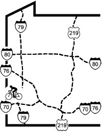
Vicinity: Directions begin headed west on US22/30 (Parkway West) from Pittsburgh.
Eastern (PA) trailheads: Take I79 south from the Parkway West, and then take the first exit (Carnegie, exit 57).
Walker’s Mill: At the bottom of the ramp turn right on Noblestown Rd. After a mile and a half on Noblestown Rd, turn left on Walkers Mill Rd, toward the Collier Twp Municipal Building. Follow this road around a couple of corners to trailhead parking on the right and left.
Sunnysoide: MP12 (40.3943,-80.1427), plus code 86GX9VV4+PW
Gregg Station: : MP13 (40.4063,-80.1649), plus code 86GXCR4P+G2 >>
Oakdale: At the bottom of the ramp turn right on Noblestown Rd. After 6.5 miles on Noblestown Rd, turn left on PA978. Follow this road a block across the creek and the trail to parking on the left.
Scotch Hill Road: MP15.635 (40.3898,-80.1984), plus code 86GX9RQ2+XM
Cemetery Hill Road: MP17 (40.3791,-80.2134), plus code 86GX9QHP+JM
McDonald: At the bottom of the ramp turn right on Noblestown Rd. After a little over 9.5 miles on Noblestown Rd, turn left on PA980. Follow this road for a block across the creek and the trail to parking on the left, in front of the Trail Station and Meeting House.
Western trailheads: Take US22 west from the Parkway West.
<<Midway: MP21 (40.3683,-80.2903), plus code 86GX9P95+8V
<<Jafree>>
Burgettstown: Take the SR18 exit, following signs to the First Niagara Pavilion. Continue south on SR18 for 3.0 miles. As you approach Burgettstown the road widens and there is a right hand road at an angle. Take this road and go 0.3 miles to the trail. Parking is on the right just after the road bends. If you miss the side road, you will pass under the trail and start to bend right. Immediately turn right on Bridge St, Go one block and turn left on N Main St. Go one block and turn right. Go one block and you will cross the trail, parking is on the left just past the trail.
Colliers (WV section): Follow US22 into WV and take Exit 3, for Harmon Ck and Cove Road. At the bottom of the ramp, turn left/south. Go 0.3 mile, crossing a bridge over Harmon Ck and the trail. Take the first right, almost a U-turn onto McColl Rd, and descend to stream level. After 0.2 miles, turn right at the sign just before the three house trailers. Trailhead parking is behind the house trailers. Biking under the US22 Bridge leads to one mile of trail that deadends. Heading away from the US22 Bridge leads towards Pittsburgh.
Panhandle Trail - Access Points
Vicinity: Directions begin headed west on US22/30 (Parkway West) from Pittsburgh.
Eastern (PA) trailheads: Take I79 south from the Parkway West, and then take the first exit (Carnegie, exit 57).
Walker’s Mill: At the bottom of the ramp turn right on Noblestown Rd. After a mile and a half on Noblestown Rd, turn left on Walkers Mill Rd, toward the Collier Twp Municipal Building. Follow this road around a couple of corners to trailhead parking on the right and left.
Sunnysoide: MP12 (40.3943,-80.1427), 86GX9VV4+PW
Gregg Station: : MP13 (40.4063,-80.1649), 86GXCR4P+G2 >>
Oakdale: At the bottom of the ramp turn right on Noblestown Rd. After 6.5 miles on Noblestown Rd, turn left on PA978. Follow this road a block across the creek and the trail to parking on the left.
Scotch Hill Road: MP15.635 (40.3898,-80.1984), 86GX9RQ2+XM
Cemetery Hill Road: MP17 (40.3791,-80.2134), 86GX9QHP+JM
McDonald: At the bottom of the ramp turn right on Noblestown Rd. After a little over 9.5 miles on Noblestown Rd, turn left on PA980. Follow this road for a block across the creek and the trail to parking on the left, in front of the Trail Station and Meeting House.
Western trailheads: Take US22 west from the Parkway West.
<<Midway: MP21 (40.3683,-80.2903), 86GX9P95+8V
<<Jafree>>
Burgettstown: Take the SR18 exit, following signs to the First Niagara Pavilion. Continue south on SR18 for 3.0 miles. As you approach Burgettstown the road widens and there is a right hand road at an angle. Take this road and go 0.3 miles to the trail. Parking is on the right just after the road bends. If you miss the side road, you will pass under the trail and start to bend right. Immediately turn right on Bridge St, Go one block and turn left on N Main St. Go one block and turn right. Go one block and you will cross the trail, parking is on the left just past the trail.
Colliers (WV section): Follow US22 into WV and take Exit 3, for Harmon Ck and Cove Road. At the bottom of the ramp, turn left/south. Go 0.3 mile, crossing a bridge over Harmon Ck and the trail. Take the first right, almost a U-turn onto McColl Rd, and descend to stream level. After 0.2 miles, turn right at the sign just before the three house trailers. Trailhead parking is behind the house trailers. Biking under the US22 Bridge leads to one mile of trail that deadends. Heading away from the US22 Bridge leads towards Pittsburgh.