|
Panhandle Trail |
one moment while we fetch a trail picture
|
|
|
Panhandle Trail |
one moment while we fetch a trail picture
|
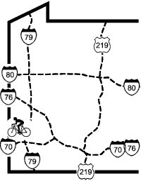
Connecting Trails

The Panhandle Trail is the first interstate trail in West Virginia and the second in western Pennsylvania (after Stavich) (described in the Northwest volume of this guide). The trail route follows the former Panhandle Branch RR for 29 miles from Walker’s Mill, in Colliers Township, west of Pittsburgh to Weirton Junction, near Weirton WV. The small town of Colliers WV is not far from the western end of the trail, so the trail is sometimes described as connecting Collier to Colliers. The trail runs through rural areas and small towns, and the wide right of way is about 75% paved with the rest crushed stone.
From the Walkers Mill Trailhead to the Allegheny/Washington county line there are white post with green lettering which starts with zero at one end of the parking lot. From Allegheny/Washington county line mileposts which start with zero somewhere in Carnegie, and measure 11.2 miles at the gate from the parking lot, and 17.2 at the county line. These mileage numbers start at the county line and are on a white 8 in, X 12 in. panel with black numbers mounted on a post about 8 feet up.
Allegheny County’s 6.7-mile section is from Walker’s Mill Rd (MP11.2) in Collier Twp. to the county line (MP17.2) just west of Laurel Hill Rd in McDonald. It connects seamlessly to 17.2 miles of the paved Washington County section which ends at the state line (MP 35.8) and connects seamlessly to 3.6 miles that end near Weirton (MP40.2).Beginning at the Walker’s Mill trailhead (MPzero), the trail almost immediately passes a rock face with a small pond at the bottom. This is one of several ponds left over from a former quarry. The windmill on the south side of the trail is pumping air into the pond to increase its oxygen content. This produces a variety of benefits, including fewer weeds, less algae growth and bottom sediment, better clarity, less odor, and a friendlier environment for fish. This area sometimes used by boy scout encampments and concerts.

<<Windmill at the Walker Mill Quary>>
There is a hiking trail at (<<MPxx>>) that crosses the creek and explores the hillside. There is a fossil cleft at MP0.8. Poke around and find a fossil from a long ago era.
Around (<<MPxx>>) during late fall and winter there is visible to the left the 1950’s vintage Nike missile site. After six creek crossings and 3.75 miles, the trail reaches the picnic pavilion and trailhead at Oakdale (<<MPxx>>). The remaining 3.4 miles into McDonald (3 in Allegheny County and 0.4 paved in Washington County) are more developed and closer to Noblestown Rd. The McDonald trailhead (MP18.2) is at the McDonald Trail Station and Meeting House, a trail information and community center on PA980, two blocks from downtown McDonald. Inside there is some of the historical information and photos of the McDonald area.
The next half-mile of trail to Primrose (MP19.7) passes through the bottomlands of Robinson Run. The high McDonald Trestle (MP19.1) that carries the Montour Trail (page PIT-31) over this valley dominates the view here. Just before Primrose there is a junction with the Montour Trail Connector (MP19.5). This side trail follows a railroad connector that provided interchange between the Montour railroad and the Panhandle Branch railroad. It leads to the Montour Trail parking area under the McDonald trestle and then across SR980 and up to the Montour Trail.
The eastern section of the trail passes by the edges of the towns of Midway (MP21.5), Bulgar(MP23.4), Joffre (<<MPxx>>), and Burgettstown (MP27.2).
At MP22.0 while traversing an old reclaimed strip mine area, there is on the right, up on the hill, a model airplane airport. Often there are model airplanes doing aerobatic maneuvers in the area.
After the last road crossing in Burgettstown (MP27.9), on the right across the ravine, is more of Burgettstown that is a company town. The homes are all the same basic shape and style, although a few have had additions added.
Soon after a deep cut (MP29.3) the trail has a distinct downhill slope to its end (MP40.2) near Weirton WV. This section is rural Pennsylvania woods with an occasional road crossing. There are no services accessible from the trail in this section.
The state line (MP35.1) is marked by a welcome sign, a railroad marker. The 3.1-mile West Virginia section is paved and reflects the more rugged topography of that state. The railroad shared a narrow valley bottom with the creek, Harmon Creek Rd, and an occasional row of houses or industrial plant, and the village of Colliers Joffre (<<MPxx>>). An old-fashioned swimming hole, complete with rope swing, is nestled near the trail near (MP1.1). The trail deadends a mile past the parking area under the US22 Bridge (<<MPxx>>).
| Location | Walker’s Mill PA to Collier WV, in Allegheny and | ||
| Trailheads | Walker’s Mill, Oakdale, Sturgeon, McDonald, Midway, | ||
| Length, Surface | 29 total miles planned; 6.7 miles packed limestone in Allegheny County PA, | ||
| Character | Uncrowded, rural, sunny, flat | ||
| Usage restrictions | No motorized vehicles | ||
| Amenities | None | ||
| Driving time from Pittsburgh | 0 hours 28 minutes |